- All
- African projects
- assessment
- assessment selected projects
- Assessment selected projects 2
- Assessment selected projects 3
- Assessment selected projects 4
- ASTRA
- Cost Benefit Analysis
- Electric mobility and ITS
- MOMOS
- planning
- planning selected projects
- planning selected projects 2
- planning selected projects 3
- planning selected projects 4
- planning selected projects 5
- projects
- Railways projects
- research
- research selected projects
- research selected projects 2
- research selected projects 3
- studies
- studies selected projects 1
- studies selected projects 2
- studies selected projects 3
- studies selected projects 4
- studies selected projects 5
- TRTingegneria
- TRUST
- urban mobility
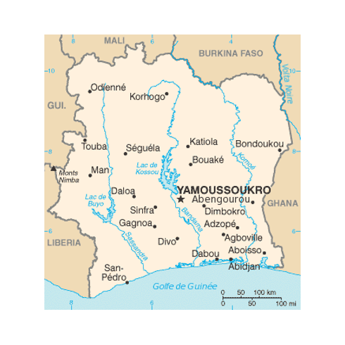
- Ivory Coast – Elaboration of the National Logistics Plan The aim of the project is the elaboration of the National Logistics Plan of the Ivory Coast with the identification of strategies for the development of logistics in the country, the drafting of an action plan and the training on the simulation model realised. The work is characterised by the performance of the following activities: collection of data and information through field interviews and desk research with reference to freight transport and logistics in Ivory Coast; processing of the data and information collected in order to provide an overview of the current state of logistics in the country, both in terms of supply and demand for freight transport; analysis of the institutional, organisational and regulatory framework of the freight transport sector in the Ivory Coast; study of the country’s freight transport and logistics development programmes for the future years; elaboration of the National Logistics Plan of the Ivory Coast. In support of the plan, TRT is also responsible for the construction of a simulation model of the demand and supply of freight transport in the country, capable of providing a forecast of demand, also in relation to the constant growth of the national GDP and the planned infrastructural interventions both on the transport network and on the main nodes (such as, for example, distribution centres and port terminals).
- Design and assessment of the National E-Mobility Strategy in Jordan Electrification is one of the main options towards decarbonizing the transport sector. The Jordanian transport sector, currently reliant on fossil fuels, accounts for nearly 40% of the energy consumption in the country in 2020. Transport decarbonisation has to be addressed to achieve Jordan’s ambitious Nationally Determined Contribution (NDC) goals. From electricity-sector perspective, uncontrolled electric vehicle (EV) uptake may bring challenges such as increase in peak load and distribution grid congestion, but also present financial and technical opportunities due to new revenue streams. Seeing the potential and benefits of E-Mobility uptake, the Government of Jordan has included Designing a National E-Mobility Strategy as part of its Reform Matrix, under Pillar 9 Energy. To this end, the Ministry of Energy and Mineral Resources (MEMR) has been leading the effort in coordination with key stakeholders and implementing partners. The World Bank (WB), through the Jordan Growth Multi-Donor Trust Fund (MDTF), supports MEMR and GoJ in its mandate with required Technical Assistance (TA) activities. This project will inform the WB’s policy dialogues in Jordan related to scaling up E-Mobility, in the context of the GoJ’s effort to design, launch, and implement a National E-Mobility Strategy. This study will have a particular focus on energy-sector issues (notably charging infrastructure and charging tariff), but also build upon past efforts, consolidate previous findings, systematically assess the key issues at stake, and provide valid and actionable options in order to support GoJ’s formulation of a comprehensive National E-Mobility Strategy. TRT, supported by MRC (Spain), is leading the project and is responsible for the design and assessment of the strategy. As part of its activities TRT has developed the Jordan vehicle fleet model to forecast the uptake of electric mobility.
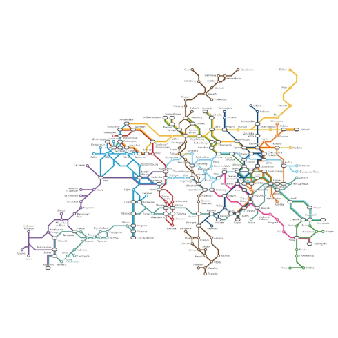
- Scoping and Feasibility Study for a European Transport Market Study Client: RailNetEurope (RNE) RailNetEurope (in short, RNE), commissioned the consortium formed by TRT (lead) and HaCon a scoping and feasibility study for the development of a freight transport market study at the European level (European Transport Market Study, or ETMS). The need to investigate the technical characteristics, and the potential use cases of such a study stems from the scarce diffusion and lack of application of the Transport Market Studies made by individual European Rail Freight Corridors (RFCs) in the past. A European-level study would overcome the drawbacks identified with previous studies and would concretely support the necessity of optimising and coordinating efforts aimed at increasing the modal share of rail freight transport, in line with EU policy targets. The research process underlying the feasibility study was first grounded on a thorough analysis of existing RFCs’ Transport Market Studies, aimed at identifying the respective contents and structure, as well as the data sources and databases employed; further, the employment of EU-scale models was assessed with respect to the purposes of simulation and forecasting, and a wide stakeholder consultation strategy was activated, bringing i.a. infrastructure managers, railway undertakings, associations, port terminals, and members of the Rail Freight Corridors to the table. The project delivered a feasibility study with an accurate assessment of the actual possibility of making a Transport Market Study at the European scale, based on both the availability of necessary data and analytical tools, as well as the need to adequately and efficiently respond to the requests brought up by stakeholders. Specifically, several options for realising the study have been evaluated, accompanied by the definition of required analytical tools and methodologies. Based on the best solution, the main components of the actual study have been set, and guidelines for its realization have been redacted. For more information: RailNetEurope istitutional websire Dedicated page for Rail Freight Corridors
- Feasibility study of the ‘Shuttle’ service within the Cesano Boscone municipal area TRT was commissioned by the Municipality of Cesano Boscone to analyse the feasibility of implementing a public transport service within its territory. The study is focused on the definition of possible alternatives that are functional to the local context. To this end, TRT reconstructed the territorial cognitive framework, identifying the current road classification, the demographic evolution of the target population groups (over 65 and under 14) and its territorial distribution. Similarly, poles of attraction within the municipal territory were identified, both in terms of services to the population and commercial areas. The cognitive framework is concluded by the analysis of current LPT services, identifying the lines and routes and their timetables, and by the analysis of the overall travel demand described by the origin-destination matrix of the Lombardy Region. Following the analysis of the municipal local public transport service decommissioned in 2011, TRT proposed two general functional solutions and the relative management models, declining them on the basis of some important realisations already active at a European and national level. TRT proposed the implementation of a timetable-based car line to cover the deficiencies identified for the service already in operation along a route connecting the Tessera locality with the centre of Cesano Boscone. The second alternative consists of a flexible service upon request. TRT has presented the administration with several alternatives based on a number of active case studies. TRT will complete the work by defining the preliminary economic framework including a description of how the service will be entrusted, following an integration of the cognitive framework that the municipality wished to complete by distributing a questionnaire to the population. [tw_button icon=”” link=”https://www.trt.it/en/Projects/” size=”small” rounded=”false” style=”flat” hover=”default” color=”#223468″ target=”_self”]Projects[/tw_button]
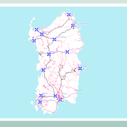
- Consultancy assignment for specialist transport engineering activities related to the “Pre-feasibility study for a regional railway network in Sardinia” on behalf of Uniontrasporti TRT collaborated with GVG Engineering on an in-depth study on the current railway network in Sardinia, defining its characteristics and potential, for a study requested by Uniontrasporti. TRT analyzed the current railway network in terms of extension and technical characteristics of both the Rete Ferroviaria Italiana (RFI, main Italian railway infrastructure manager) and secondary narrow-gauge (ARST) networks; the analysis of services offered; the analysis of production nodes and tourist demand; the definition of the needs of the local population to favor the accessibility of inner areas and support regional economic development; the definition of requirements; and the identification of modal interchange points between passenger services. This was accompanied by an analysis of the interventions planned on networks according to the Economy and Finance Document 2022 (“Documento Economia e Finanza” of Italian government), the Framework Agreement between the Region of Sardinia and RFI, the RFI 2022 Business Plan, regional planning instruments, and the three-year plan of works of ARST. The services description was based on an analysis of the timetables published on institutional websites of individual organizations. The analysis focused also on tourist services, such as the Green Train (“Trenino Verde”, a touristic service on dismissed rail lines), and urban services, above all MetroCagliari and MetroSassari. This analysis led to the identification of interchange nodes, which were described in terms of the services present. The demand analysis completes the definition of the knowledge framework, identifying the main municipalities in terms of population and employees, tourist demand over the years and identifying the most attractive municipalities. Eventually, the definition of needs analyses the information gathered during several meetings held with local stakeholders, trying to define the priorities of the territory. The study is completed by the description of possible project interventions, constraints and criticalities of the network, which TRT supported in defining.
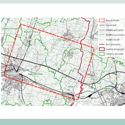
- Traffic study on the opening of an exit along the A1 near Gavassa, Reggio Emilia TRT was commissioned to draw up a traffic study to evaluate the opening of a new exit along the A1 motorway, between Reggio Emilia and Correggio. The study saw the implementation of a macroscopic traffic model, a useful tool for the evaluation of the different hypotheses considered. A territorial analysis of the area in included, with an in-depth study of the characteristics of the road network and the traffic demand in the area, with the analysis of the origin-destination matrix of the regional model, the available traffic counts and an on-site inspection which included specific traffic counts. All these information were used to calibrate the model. The following step was the reconstruction of the reference scenario, with respect to the year 2040, in order to include in the model all the road interventions planned by regional and local administrative divisions. The traffic model was thus used to evaluate five different project hypotheses, evaluated at the year 2040: a three-way exit with connection to the ordinary road network, subject to redevelopment, to the south of the motorway axis a trumpet exit with connection to the ordinary road network north of the A1, subject to redevelopment an exit with separate functions which has an entrance to the north and to the south of the motorway; the hypothesis of a parallel road of A1 motorway which connects the Prato-Gavassa area with the ordinary road network in Via Gramsci (Reggio Emilia); the hypothesis of a parallel road of A1 motorway which connects the Prato-Gavassa area with the access road to the Reggio Emilia tollgate, including an overpass of Via Gramsci.
- Effects of pricing policies on the Superstrada Pedemontana Veneta – Surveys, analysis and proposals The study evaluated the effects of different toll schemes on Superstrada Pedemontana Veneta traffic forecasts using the PTV Visum traffic assignment software package. The toll schemes were designed combining different combinations of toll levels, modulated according to both vehicle type and geographical area of origin for passenger and freight traffic. The alternative toll schemes were designed also taking into account the outcome of a series of interviews aimed at identifying the demand for commercial vehicles that could potentially be attracted to the new road infrastructure. The survey directly involved both local and international companies, logistics operators, sector and trade associations that would be potentially interested in using the motorway infrastructure. The survey questionnaire was aimed at understanding the respondents’ needs and requirements as well as their point of view in terms of advantages and disadvantages of using the infrastructure considering time, costs, quality of services and parking areas availability.
- European Urban Mobility Observatory and support (ELTIS) and Urban Mobility Scoreboard (SUMI – Sustainable Urban Mobility Indicators) ELTIS, the European Urban Mobility Observatory, is a long-standing web portal (eltis.org), which has facilitated the exchange of information and best practice in the field of urban mobility in Europe for over 20 years. Financed by DG MOVE, ELTIS has expanded its remit over time, evolving from an information repository, to become the EU’s Urban Mobility Observatory. As such, ELTIS now provides a broad range of essential services (e.g. training and support tools) and became a one-stop shop for sustainable urban mobility plan (SUMP) guidance, following the integration of the European Platform on SUMPs into a new portal hosted on the European Commission website (Urban Mobility Observatory). To support the use of the SUMP guidance material available on ELTIS, the SUMI (Sustainable Urban Mobility Indicators) project aimed at developing a set of indicators to enable cities to identify deficiency areas and enhance alignment with EU policy goals. The ultimate goal has been the definition of indicators covering the seven indicator areas mentioned in the draft amended TEN-T Regulation, together with the development, implementation, and analysis of responses to a European-wide urban mobility data and indicators survey of cities proposed to be ‘urban nodes’ in the draft TEN-T Regulation. This project extends the legacy of the ELTIS portal, managed for the period 2022-2023, and updates and enhances SUMI to support the amendment of TEN-T Regulation. After having been already involved in both the previous ELTIS (2017-2021) and SUMI (2018-2020) projects, TRT has been awarded for the combined ELTIS-SUMI 2 project, as part of an international consortium led by Ricardo (UK), with Rupprecht Consult (DE), POLIS (BE), ECORYS (ML), TEPR (UK), Vision5 (AT), UITP (BE), TML (BE) and Marlon (BE). TRT contributes to the project as it comes to: publishing news items and case studies on the ELTIS Portal, and drafting new SUMP Topic Guides / Practitioner briefings, to facilitate the continued dissemination of best practice information to urban mobility professionals across Europe, chairing and organising meetings of the EU SUMP Platform Coordinating Group, bringing together representatives of the main ongoing and EU funded projects on SUMP, reviewing, updating and simplifying the set of SUMI indicators related to the indicator areas of the amended TEN-T Regulation, exploring data availability among the cities defined as urban nodes across Europe. For more information: SUMI website Previous ELTIS contract Previous SUMI contract [tw_button icon=”” link=”http://www.trt.it/en/Projects/” size=”small” rounded=”false” style=”flat” hover=”default” color=”#223468″ target=”_self”]Projects[/tw_button]
- Passenger demand for small aircrafts until 2050: design and application of a modelling tool to simulate future scenarios The background of the study is the European Clean Sky 2 programme, aiming at developing innovative technologies to reduce emissions and noise levels from aircrafts, while simultaneously developing and strengthening a globally competitive aeronautical industry in Europe. The scope of the programme does also include Small Air Transport (SAT), which is expected to contribute to the connectivity of remote regions in Europe and the rest of the world. The study provided an ATS level assessment and forecasts for Small Air Transport aircrafts, namely airplanes with passenger capacity between 9 and 19 seats and pressurized and unpressurized cabin compartment. A modelling tool has been developed to provide (i) the assessment with respect to passenger volume, fleet and flights for the base year 2019 and (ii) results for future years from 2025 to 2050 in five years steps. The main activities of the project have been related to: Review and analysis of available SAT concepts and potential business models; Design and development of the model for the estimation of demand for Small Air Transport aircrafts at European scale, supported by the related data collection and calibration process. The model is also accompanied by input and output interface, complemented with a user guide; Application of the model to forecasts future potential SAT demand for the reference scenario and two alternative scenarios by 2050; Analysis of European modelling results to evaluate the potential SAT demand for the rest of the world with a qualitative approach. TRT led the project and covered all the activities related to the model design, development and application. The subcontractor SEO Amsterdam Economics focused on the review of SAT concept and business models. For more information: Official site of Clean Aviation programme: description of Small Air Transport Transversal Activity.