- All
- African projects
- assessment
- assessment selected projects
- Assessment selected projects 2
- Assessment selected projects 3
- Assessment selected projects 4
- ASTRA
- Cost Benefit Analysis
- Electric mobility and ITS
- MOMOS
- planning
- planning selected projects
- planning selected projects 2
- planning selected projects 3
- planning selected projects 4
- planning selected projects 5
- projects
- Railways projects
- research
- research selected projects
- research selected projects 2
- research selected projects 3
- studies
- studies selected projects 1
- studies selected projects 2
- studies selected projects 3
- studies selected projects 4
- studies selected projects 5
- TRTingegneria
- TRUST
- urban mobility
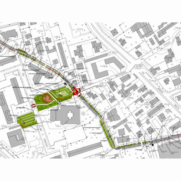
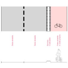
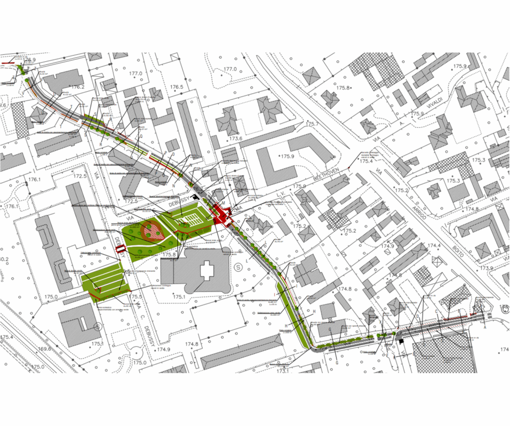
- Drafting of a Technical and Economic Feasibility Study (PFTE) for a cycle path along Via della Birona in Monza TRTIngegneria was commissioned by architect Andrea Nonni to assist in the preparation of project design documents for the Municipality of Monza’s participation in the Lombardy Region’s ‘Strade Verdi’ (Green Roads) tender. Specifically, the contribution is required for the drafting of the PFTE (Preliminary Technical Project) of a cycle path along Via della Birona in Monza, Italy and the related works for its inclusion in the areas in front of the entrance to the nursery and primary schools in Via Debussy. The project involved the construction of a one-way cycle path along the entire length of Via della Birona, divided into two sections (one one-way northbound in the southern part and one southbound in the northern part of Via Beethoven). The infrastructure integration work included: • the renovation of the car park along Via della Birona, with the use of draining paving and devices for groundwater filtration; • the implementation of speed reduction measures along Via della Birona and Via Debussy, through the construction of a speed bump at the intersection with Via Beethoven and a raised crossing on Via Debussy; • the construction of new paving for the parking areas in front of schools that allows rainwater to filter through, including a filter tank; • green spaces with plants capable of filtering atmospheric pollutants, accompanied by a playground, pedestrian areas serving schools to improve their accessibility, together with bicycle parking facilities (racks), benches and other street furniture.
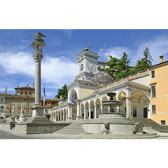
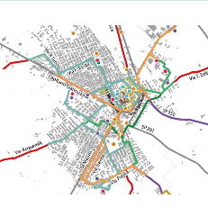
- Drafting of the new Sustainable Urban Mobility Plan and updating of the General Urban Traffic Plan for the city of Udine After a tender process, TRTIngegneria, in partnership with ISFORT Istituto Superiore di Formazione e Ricerca per i Trasporti, Ambiente Italia and GVG Engineering, was selected by the Municipality of Udine to draft the city’s first Sustainable Urban Mobility Plan (SUMP) and update its General Urban Traffic Plan (PGTU). With regard to the PUMS, the working group’s activities are structured according to the following methodological steps, in line with the 2019 guidelines of the Ministry of Transport and the new Regulation (EU) 2024/1679 (the city of Udine is a TEN-T urban node): All phases are accompanied by a broad and structured communication and participation campaign, which involves citizens and stakeholders through public meetings, technical round tables, focus groups and online questionnaires. The PGTU is developed on the basis of the objectives and measures defined in the short-term scenario of the PUMS, detailing the characteristics and feasibility of the individual actions. During the drafting of the PGTU, a series of urban traffic nodes are subject to detailed assessment through the application of a micro-dynamic simulation model (VISSIM) integrated with the multimodal model developed for the PUMS.
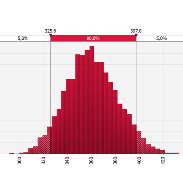
- Feasibility project of the mass transport system for the connection between the area of the railway station located in Latina Scalo and the city centre TRTingegneria as member of the consortium formed by Tecnosistem (leader) and One Works (partner), has been commissioned to draft the Technical and Economic Feasibility Project – PFTE – for the public transport connection between the railway station (located in Latina Scalo) and the city center of Latina. Within the project, TRTIngegneria is responsible for the preparation of the cost-benefit analysis and risk analyses. The Cost-Benefit Analysis evaluates, by comparison, different alternatives of the public transport lines’ routes through the calculation of their main economic indicators (Economic Net Present Value – ENPV and Economic Internal Rate of Return – EIRR). The basic approach of every evaluation is the comparison of different alternative scenarios against the reference scenario of no project implementation. The analysis is conducted considering the MIT Guidelines for the evaluation of investments in public works (2017) and the recent Addendums for the submission of applications for access to resources designated for Rapid Mass Transport by Fixed Installations and for the evaluation of railway projects (2021). As required by the ministerial guidelines, the economic analysis is accompanied by the qualitative risk analysis and the quantitative risk analysis, that has been developed using the specialized software (@Risk). The @Risk software employs Monte Carlo simulation, a statistical technique that involves running multiple simulations using random variables to generate possible outcomes for a decision or event. The quantitative risk analysis is enhanced with sensitivity analysis, scenario analysis, and their optimization. For the main statistical variables (e.g., investment costs, operational costs, benefits, etc.), the software allows choosing from numerous distribution curves and generates numerical and graphic outputs with the calculation of P90 and/or P80 and P50 probabilities for the results of the analyses conducted.
- Technical assistance to assess the potential demand for a public transport system in the ceramic district area and connections to Modena The Transport Infrastructure and Sustainable Mobility Sector – General Directorate for Territorial and Environmental Management of the Emilia-Romagna Region entrusted TRT Ingegneria with the “Technical assistance aimed at assessing the potential demand for a public transport system in the area of the ceramic district and connections with Modena”. The purpose of the study was to carry out an analysis of possible alternatives for the local public transport system along the corridor between Sassuolo and Vignola. In the first instance the study analysed the main characteristics of the area considering: current rail and road public transport offer, both in terms of routes and active services; travel demand based on available sources, both local and regional. In particular, reference was made to the Origin-Destination (OD) matrices estimated by PRIT2025, the PUMS of Modena and the Distretto Ceramico, as well as data on the demand transported by LPT services in the area; various sector planning documents currently in force, in order to better understand what is envisaged in the corridor under study. Starting from this knowledge base, the study identified five different alternatives for new public transport services between Sassuolo and Vignola for a subsequent preliminary assessment. The preliminary assessment cross-referenced demand data with supply data referring to the different systems (capacity, performance, costs, investment and management, etc.) and was complemented by a multi-criteria analysis that followed three main steps: definition of evaluation criteria and sub-criteria; estimation of the criteria weights through the involvement of local administrators and stakeholders by means of interviews; normalisation of the measurements to ensure comparability.
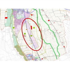
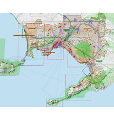
- Urban reorganization and landscape requalification sheet – Logistic hub in Isola della Scala The Municipality of Isola della Scala, affected by the provisions of the «Quadrante Europa Area Plan» (PAQE), which include – among others – the development of a logistics hub on its territory, has entrusted TRT Ingegneria with the service of drafting a Masterplan called «Urban reorganization and landscape requalification sheet». The focal point of the logistics hub is the provision for an intermodal centre, an infrastructure specialized in rail-to-rail and rail-to-road exchange functions located along the Verona-Bologna railway line (on the Brenner route and part of the TEN-T «Scandinavian-Mediterranean» corridor). Methodologically, the drafting process of the Masterplan is structured into the following macro-actions:
- Drafting mobility scenarios for the Territorial Plan for the Metropolitan City of Naples TRTIng, grouped with Telos, Ambiente Italia, Geores, Nemo and Sociolab, was in charge of drafting the Territorial Plan of the Metropolitan (PTM) City of Naples. In particular, TRT supports the working group in analyzing the current assets of mobility and transport infrastructures and in defining future policies and interventions taking into account the SUMP (Sustainable Urban Mobility Plan) of the Metropolitan City currently being adopted. The PTM of the Metropolitan City of Naples wants to be a shared territorial project to effectively pursue the objectives of sustainable development and the reduction of land consumption, strengthening and enhancing the infrastructure networks and public mobility systems in synergy with the SUMP. The plan focuses on urban regeneration and on the redevelopment of the existing building heritage, the upgrading and redevelopment of services and public spaces, the construction of the metropolitan ecological network as well as the protection and enhancement of all landscapes.
- Cesena Sport City: network of cycling routes connecting sports areas in Cesena Following the victory in the design competition organized by the Municipality of Cesena in 2021, TRTIngegneria is developing a project for cycling connections as part of a broader activity to prepare the final and executive project, as well as safety coordination, aimed at the redevelopment of five sports areas. The project is named «Cesena Sport City». TRTIngegneria is working in partnership with Degli Esposti Architetti Srl (lead partner), CEAS Srl, various professional architects, engineers, and geologists (Elisa Cristiana Cattaneo, Angelo Bolzoni, Umberto Guerra, and Marcello Brugola), and benefits from the technical consultancy of GVG Engineering Srl. Specifically, TRTIngegneria’s activities involve defining and subsequently designing some cycling routes connecting the city center and the new sports hubs covered by the project. In the development of these activities, a methodology is adopted to emphasize and achieve: the construction of a cycling infrastructure based on the concept of a «city for diachronic sections», which means a timeline that can be traversed with slow mobility for daily commuting; strengthening the «Bicipolitana» and the «VeloCe» projects (as planned in the Cesena SUMP); weaving together internal molecular structures, redeveloping and enhancing existing routes, and implementing small actions through the construction of new sections that integrate existing elements; connecting with bike sharing and bike stop points in the project areas, creating small exchange hubs between motorists and cyclists. The use of roads as public spaces and the desire to establish a direct relationship between the city and the surrounding areas lead to proposing actions that aim to question and overturn the current car-pedestrian and car-cyclist hierarchy, reallocating space from parked cars to improve the usability of public spaces.
- Drafting of the Cycling Mobility Plan of the Municipality of Ugento (Salento), strategic vision to promote cycling for daily travel and for tourism The Municipal Administration of Ugento has entrusted “TRT Ingegneria” with the drafting of the Municipal Cycling Mobility Plan, after obtaining funding from the Puglia Region in 2021. The territory of Ugento is characterised by a strong vocation for tourism. This is due to the possibility of taking advantage of its numerous natural and environmental resources, including its marinas and parks, as well as the presence of a significant historical and cultural heritage. The primary public will for the area is to enhance and support the tourism system, and in this regard, cycling plays a particularly important role. Given the characteristics of the city of Ugento, the proposed bicycle network is developed by integrating the central urban area with the extensive network of existing suburban paths and white roads. This is done to define a complete active mobility network in the entire municipal territory that supports not only daily movements but also recreational and leisure trips. The Cycling Plan proposal considers as a starting point some references projects that involve the municipal territory at various levels. These are “La ciclovia dei Tre Mari”, the ongoing “Project for the construction of bicycle paths in the municipality of Ugento” and the proposal contained in the “Plan for the Ugento Litoral Regional Natural Park “. The plan elaboration was structured in two phases: The first phase, called “Cognitive framework and guidelines”, contains the analysis of the current state of cycling mobility in Ugento. It analyses the supply and demand of cycling routes and related services, as well as the social and environmental impacts. This document also contains the regulatory, planning and programming framework. The second phase, called “Drafting the Plan Document”, contains the definition of the objectives and strategies, as well as the description of the method used to identify priorities for action. The document presents the design of the cycle network, identifies services dedicated to cycling, and communication activities to encourage cycling. Finally, the document is completed by the investment cost estimation and the definition of the indicators for monitoring the planned actions. The Plan was adopted by the Municipal Council on 26.01.2023 and received the declaration of non-subjection to the Strategic Environmental Assessment (SEA) on 21.04.2023 by the competent Authority. On 05.07.2023, it was approved by the Municipal Council.
- Drafting of the executive design including the elements of the definitive project necessary for the Services Conference of two parts of the VENTO cycle route between Piacenza, Fossadello and Cremona TRTIngegneria was commissioned by AIPO to draw up the executive design of two sections of the VENTO cycle path: the Piacenza-Fossadello priority lot and the Fossadello-Cremona lot E1. The second mentioned lot is financed by funds linked to the National Recovery and Resilience Plan. Starting from the Technical-Economic Feasibility Project developed at an interregional level, TRTingegneria develops the executive project of the lots indicated above, in particular the in-depth study of the detailed aspects, by means of a chorography of the framework, the plan of the project insertion both on aerial photos and on CTR, the list and analysis of prices with the incidence of labour, the metric computation, the economic framework, the report on the excavated soil and rocks and the descriptive-performance specifications of the work. As for the specialised reports, TRTingegneria develops the geological and geotechnical report in addition to the hydrological and hydraulic report, the environmental report, the preventive check of archaeological interest, the technical report of the electrical systems, the interference resolution and their planimetry. On the urban planning side, landscape and historical/cultural constraints are analysed, as well as interferences with the Natura 2000 Network and the drainage and irrigation system. Similarly, the technical maps of the municipal regulatory plans (or similar instruments) will be analysed to verify the project’s inclusion. Finally, TRTingeneria develops the road design of the cycle track, with detailed plans on planimetric survey, with details of intersections, longitudinal profile, current and typological sections. Road construction details, signage, parking areas, water collection system and electrical installations are also included.