The participation in research projects in international consortia allows TRT staff to develop new methodological approaches, analyse the latest technologies made available on the market, develop innovative mobility policies, etc.
The in-depth knowledge of the decision-making processes, associated with quantitative analysis capabilities, allows TRT to provide valuable technical assistance and careful strategic advice to private and public operators, both at national and European levels.
Both in Italy and at an international scale, TRT provides technical assistance to decision-makers involved in the development of the trans-European networks, facilitating the growth of multimodal, efficient, integrated and sustainable transport systems.
At urban level, TRT is continuously innovating methods and analytical planning tools (both macro and micro-scale) and is active to promote the implementation of Sustainable Urban Mobility Plans in Italy and in Europe.
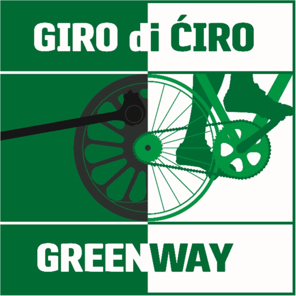
- Boosting regional economic development in the Balkans with the “Giro di Ciro” Greenway The “Giro di Ciro” is a significant transnational initiative in the Western Balkans. It aims to convert the historic Belgrade-to-Adriatic arrow-gauge railway, originally constructed in the late 19th and early 20th centuries as a vital artery for trade and communication, into an 800+ km pedestrian and cycling greenway. TRT was selected by the World Bank to support governments in the Western Balkans, particularly Bosnia and Herzegovina, in helping move the Giro di Ciro from a promising concept to practical implementation. The project includes the following activities: • Defining a shared transnational vision and narrative for the entire Giro di Ciro, including the preparation and graphic design of a promotional brochure, which also contains a cost-benefit analysis and an estimate of the project’s tourism and economic potential; • Proposing a National Greenway Framework for the development and management of a greenway network in Bosnia and Herzegovina, including the Giro di Ciro, which was discussed with the country’s most relevant institutions; • Preparing a Preliminary Study for a priority 150 km section of the Giro di Ciro in Bosnia and Herzegovina (starting from a detailed assessment of the current conditions of the former railway corridor and its surrounding context), together with a tourism development strategy for this section; • Engaging stakeholders and disseminating results, including the organization of a high-profile event in Sarajevo.
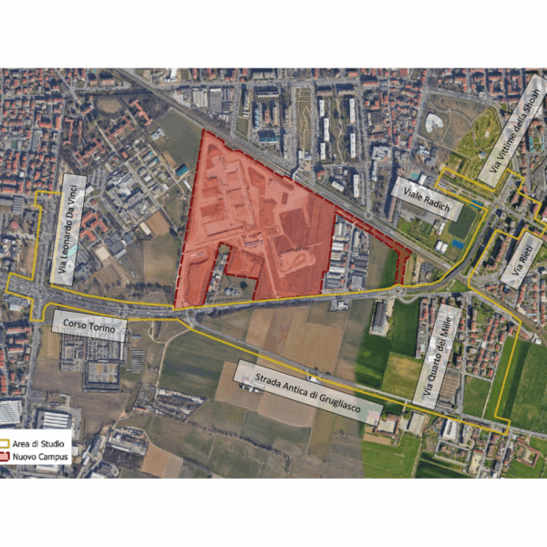
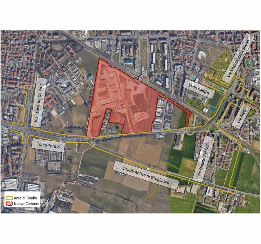
- Assessment of the impact on traffic of the opening of the new campus of the University of Turin, ‘Città delle Scienze e dell’Ambiente’ (City of Science and Environment), located in Grugliasco, Metropolitan City of Turin TRT was chosen by Zona Ovest di Torino srl to provide modelling support in defining the impact of the new campus of the University of Turin, ‘Città delle Scienze e dell’Ambiente’ (City of Science and Environment), in the municipality of Grugliasco. The new campus includes facilities for the Chemistry and Biology Departments, spaces for research, teaching and ancillary services for students, covering a total of approximately 90.000 m2 and is expected to double the university population (from the current 5,000 to approximately 10,000). The study begins with the VISUM model developed by TRT on behalf of Zona Ovest and the Municipality of Grugliasco as part of the support assignment for the evaluation of the PGTU, further refining its calibration through a traffic detection campaign. The macroscopic model was used for the municipal-scale assessment of the opening of the new campus, while the local impact assessment was carried out using a dynamic microscopic simulation model in the VISSIM environment. The study took into account various data sources, in addition to ad hoc surveys, of a demographic and statistical nature on the student population and university staff involved in the transfer (keeping teachers separate from researchers, research fellows, scholarship holders, technical and administrative staff, etc.) as well as information on the current travel habits of people who already gravitate towards Grugliasco (where the veterinary, agrovet, agricultural and “agrinnova” facilities are located), including modes of transport, weekly campus attendance, the number of years students are behind in their studies, and the location of their domicile or residence. The analyses carried out have made it possible to identify the configuration and adaptation measures for the road network that are most effective in mitigating the impact of the opening of the university campus.
- Design and technical assistance for the award of the Local Public Transport service of the Municipality of Arzachena The Municipality of Arzachena entrusted TRT with the service of “Design and technical assistance for the award of the Local Public Transport service of the Municipality of Arzachena”. The assignment involves activities aimed at the design and assistance for the awarding of the Local Public Transport (LPT) service contract for the Municipality of Arzachena. The work is structured into three main phases: •Preliminary territorial and transport analysis, aimed at understanding the territorial dynamics and the characteristics of the existing service; •Planning and design of the public transport service, consisting of the definition of the characteristics of the proposed public transport service; •Technical assistance to the procedures for the selection and award of the service, consisting of technical support to the Municipality for the preparation of the tender documents and for all phases of the award procedure. The first phase of analysis aims to reconstruct the current framework of local mobility, considering the settlement, demographic and tourist characteristics of the municipal area, as well as analysing transport demand through specific investigations. The second phase is based on the results of the knowledge framework reconstruction to develop a new transport offer configuration, consistent with the mobility needs of the different user groups, both in summer (tourists) and winter (residents), distinguishing between annual service, seasonal summer service and any flexible services. The activities also include technical assistance to the Municipality of Arzachena in the preparation of the special tender specifications, the tender rules and the service contract scheme. To date, TRT has completed the preliminary territorial and transport analysis.
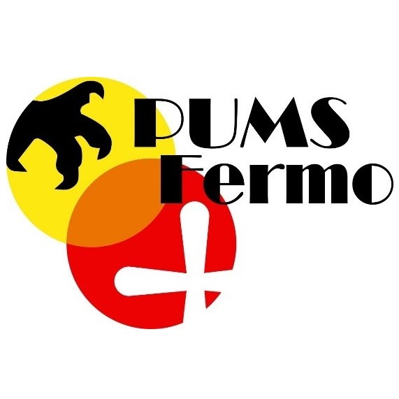
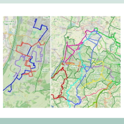
- Municipality of Fermo, Sustainable Urban Mobility Plan Following a tender procedure, the Municipality of Fermo entrusted TRT, together with local experts, with drafting the Sustainable Urban Mobility Plan (PUMS) and the related Preliminary Environmental Report – Screening procedure for Strategic Environmental Assessment (SEA).The drafting of the PUMS is structured in three phases. The first phase is related to the definition of guidelines, including the knowledge framework of the mobility system and the SWOT analysis, leading to the formulation of objectives and strategies. The planning-programming framework was defined at regional, provincial, and local levels, along with the territorial and socio-economic context of the planning area, the supply of transport networks and services, mobility demand, and the social (accidents) and environmental impacts generated by the mobility system. The second phase includes the drafting of the preliminary PUMS report, which builds on the knowledge framework to identify planning scenarios and related actions. This document allows the initiation of the SEA screening procedure, providing the essential information to assess the environmental impact of the Plan. In parallel with the first and during the second phase, a participation process was developed involving local stakeholders: initially to identify the critical issues of the mobility system and later to critically review the system of actions forming the Plan’s scenario. The feedback received helped refine the definition of scenarios based on comments and suggestions. The third phase is the drafting of the final Plan document, which includes not only the contents of the second phase but also the results of the MOMOS model application, as well as cost estimates and target indicators.
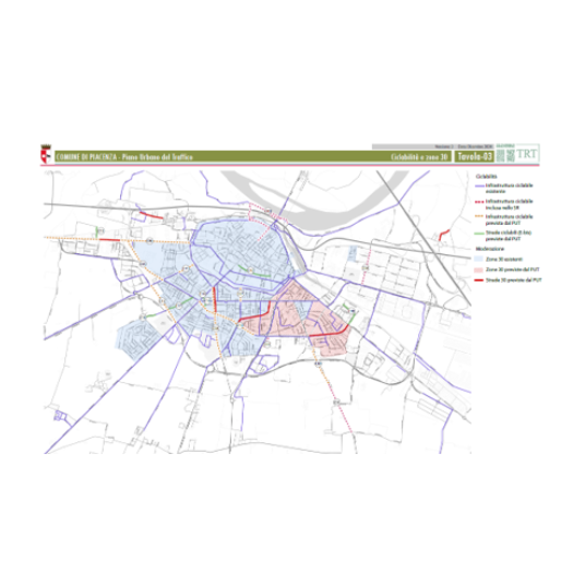
- Update of the Urban Traffic Plan (UTP) of the Municipality of Piacenza, a short-term (two-year) implementation tool of the Sustainable Urban Mobility Plan The Municipality of Piacenza has commissioned TRT to draft the monitoring report for the Sustainable Urban Mobility Plan (SUMP) (document submitted and registered on 10/08/2023) and to update the Urban Traffic Plan (UTP). The UTP is a short-term implementation plan (covering a two-year period) aimed at carrying out the interventions foreseen in the Short-Term Scenario of the SUMP. The development of Piacenza’s UTP follows the guidelines set out in the Ministerial Directives of 1995 and the most recent updates to the Italian Highway Code. The monitoring of the SUMP lays the foundation for selecting the interventions that define the scenarios of the UTP. In fact, the document reports on the updated state of urban mobility in Piacenza, assessing the progress and impacts of the actions taken since the approval of the SUMP in December 2020. Based on this evidence, the most consistent interventions with the SUMP’s short-term scenario (2–3 years) have been selected. This selection also considered existing planning tools, such as the 2024–2026 Three-Year Public Works Program, the Cycling Plan (approved on 17/04/2023), the Smart City Plan (October 2019), the Environmental Noise Action Plan, and other strategic documents. The UTP was developed in three main phases: With Municipal Resolution No. 23 of 11 February 2025, the Draft Plan was adopted. Following the 30-day period dedicated to public consultation, and the related replies/amendments, the Plan was definitely approved by the Municipal Council with Resolution No. 25 of 22/09/2025.
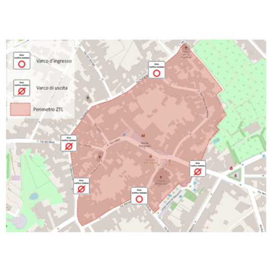
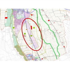
- Study to identify the perimeter of a Restricted Traffic Zone within the inhabited area of Cusago (Milan) TRT was commissioned to carry out a study aimed at identifying the correct perimeter of a Restricted Traffic Zone (ZTL) for commercial vehicle traffic to be placed within the inhabited area of Cusago, a municipality of the Metropolitan City of Milan. The implementation of the ZTL for heavy vehicles is intended to solve the problem of heavy vehicles crossing residential areas, where today a ban on access is in force, which is frequently not respected. The study included: Photographic overview of planned access points location
- Drafting of the Urban Plan of Sustainable Mobility of the Municipality of Monteroni di Lecce(LE) accompanied by verification of subjection to strategic environmental assessment (SEA) The Municipality of Monteroni di Lecce (LE) has entrusted TRT Trasporti e Territorio with the service of drafting the Sustainable Urban Mobility Plan (PUMS). The Plan is financed by the Apulia Region as part of the authority’s commitment to provide municipalities with strategic planning tools for the urban mobility and transport sector. TRT was chosen by the Administration in continuity with the recent work carried out for the elaboration of the General Urban Traffic Plan (PGTU), approved by the City Council in April 2024.Starting from the knowledge of the territory acquired thanks to the previous PGTU, TRT has drafted the PUMS, a Pano document of a strategic nature with a 10-year time horizon, which represents a medium-long term guide capable of orienting the Administration’s decisions in the field of mobility.The drafting of the PUMS developed through two phases. The first consisted in drafting the Plan’s Guidelines, containing the cognitive framework, the SWOT analysis and, consequently, the Plan’s objectives and strategies, including the description of indicators. The cognitive framework included the superordinate planning framework, the analysis of mobility demand, infrastructure and services endowment, the position of traffic attractors as well as information related to mobility impacts (pollutants, accidents, motorisation rate, etc.).The second phase included the identification of alternative Plan scenarios, monitoring, cost estimation, the results of the Plan Scenario assessment through the implementation of the strategic model MOMOS (MOdello per la MObilità Sostenibile) with the consequent extraction of transport, environmental, social and economic sustainability indicators. MOMOS was applied to assess, in an aggregate way, the impact of the mobility policies introduced, such as the expansion of the bicycle network, new public transport services, the ZTL, speed moderation, etc.. A screening report was also prepared to accompany the second phase, in order to evaluate the exclusion of the Plan from the SEA process by the competent authority. Monteroni SUMP was adopted with resolution n. 136 in the 8th on November 2024 by the Town Government Council and approved with resolution n. 6 in the 12th February 2025 by the Town Council.
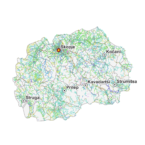
- Technical Assistance for Development of Sustainable Urban Mobility Plans for five Municipalities and providing training on developing and implementation of Sustainable Urban Mobility Plans North Macedonia faces significant challenges in managing its extensive local road network, which spans approximately 9,000 kilometers and falls under the jurisdiction of decentralized municipalities. Many of these municipalities lack the capacity and resources necessary for effective infrastructure maintenance, resulting in deteriorating road conditions that limit access to essential services and opportunities, ultimately affecting citizens’ quality of life. Developing a well-structured Sustainable Urban Mobility Plan (SUMP) is crucial to addressing these challenges and achieving the aforementioned objectives. The primary objective of this project, financed by the International Bank for Reconstruction and Development – World Bank, is to develop the SUMPs for the municipalities of Kavadarci, Kochani, Struga, Strumica, and Prilep by enhancing accessibility, promoting health and safety, supporting economic growth, and mitigating environmental impacts. This will be achieved through the promotion of sustainable transport modes, and the adoption of low-carbon initiatives aimed at reducing emissions and optimizing traffic flow. The SUMP development process aligns with European guidelines and is divided into two macro-activities:
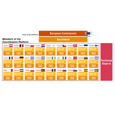
- Technical secretariat of the coordination platform to support Member States in implementing requirements for urban nodes in the revised TEN-T Regulation The European Commission’s Sustainable and Smart Mobility Strategy outlines a roadmap for achieving a sustainable, smart, and resilient transport system, with cities playing a central role in this transition. By 2030, all cities are expected to develop Sustainable Urban Mobility Plans (SUMPs) to drive this transformation. The New Urban Mobility Framework further emphasizes the importance of integrating cities and regions into the Trans-European Transport Network (TEN-T) by improving first and last-mile connections for both passengers and freight. Ensuring better coordination among local authorities is key to achieving this goal. To support these efforts, the revised TEN-T Regulation designates 432 urban nodes and establishes key requirements to be met by 31 December 2027. These include: To facilitate the implementation of these requirements, a coordination platform is being established. This platform serves as the main forum for exchange and collaboration among EU Member States, supporting the rollout of SUMPs and urban mobility indicators (UMI). By fostering knowledge-sharing and cross-border cooperation, it aims to ensure a consistent and high-quality approach to urban mobility across Europe. The platform’s technical secretariat is coordinated by PwC, with TIS, TRT, and ICLEI integrating the consortium. TRT leads Task 2, a pivotal component of the project that focuses on providing expert advice for implementing the urban node requirements. Key responsibilities include:
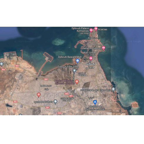
- The Djibouti authorities have appointed the consortium led by IDEA Consult to develop a long-term vision for urban mobility and an action plan for the short, medium and long term, taking into account climate change and its impact on transport networks. The aim of the project is to address the problems of the capital’s transport system, which are undermining its functionality. The study will be carried out in three phases An initial diagnostic phase of the urban transport system, which includes analysing demand, surveying the current state of the road infrastructure and constructing a macro and micro model. A second phase consisting of two main activities: a short-term priority investment programme providing rapid responses to problems, and the development of a shared long-term strategic vision for the urban transport system. Finally, a third phase will be the definition of the master plan for the urban road system. Within the consortium TRT will be responsible for:
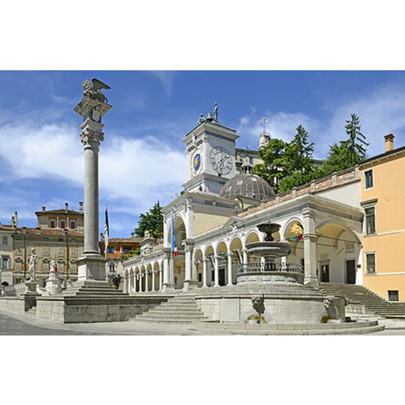
- Drafting of the new Sustainable Urban Mobility Plan and updating of the General Urban Traffic Plan for the city of Udine After a tender process, TRTIngegneria, in partnership with ISFORT Istituto Superiore di Formazione e Ricerca per i Trasporti, Ambiente Italia and GVG Engineering, was selected by the Municipality of Udine to draft the city’s first Sustainable Urban Mobility Plan (SUMP) and update its General Urban Traffic Plan (PGTU). With regard to the PUMS, the working group’s activities are structured according to the following methodological steps, in line with the 2019 guidelines of the Ministry of Transport and the new Regulation (EU) 2024/1679 (the city of Udine is a TEN-T urban node): All phases are accompanied by a broad and structured communication and participation campaign, which involves citizens and stakeholders through public meetings, technical round tables, focus groups and online questionnaires. The PGTU is developed on the basis of the objectives and measures defined in the short-term scenario of the PUMS, detailing the characteristics and feasibility of the individual actions. During the drafting of the PGTU, a series of urban traffic nodes are subject to detailed assessment through the application of a micro-dynamic simulation model (VISSIM) integrated with the multimodal model developed for the PUMS.
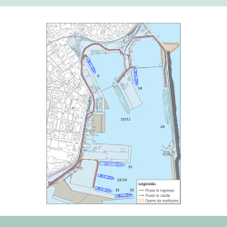
- Port of Livorno and Interporto Vespucci – Development and interaction between the Rail Plan and Darsena Europa The study, developed on behalf of Vega Engineering for the AdSP of the Northern Tyrrhenian Sea, was aimed at the functional analysis of the port – freight village system in the Livorno area to assess its potential and opportunities following the realisation and full implementation of the Piano del Ferro and the Darsena Europa. To this end, a cognitive framework was defined on the characteristics of supply and demand, current and future, of the port-freight village system and the definition of the functional evolution of the system in relation to the realisation of the planned infrastructural interventions around it. To support the definition of the port and freight village system, an analysis of the main Italian freight villages was also carried out in order to identify their characteristics, good practices and strong points to be transferred, if necessary, to the specific context of Livorno. Following the definition of the evolutionary scenarios, the infrastructural potential of the intermodal terminal was verified, and the future prospects of the entire port-freight village system were assessed, integrating this activity with the support of a simplified economic-financial analysis for the various evolutionary scenarios.
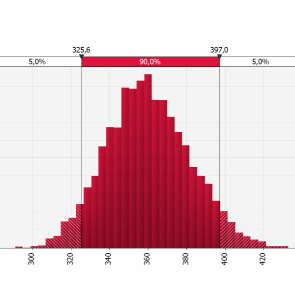
- Feasibility project of the mass transport system for the connection between the area of the railway station located in Latina Scalo and the city centre TRTingegneria as member of the consortium formed by Tecnosistem (leader) and One Works (partner), has been commissioned to draft the Technical and Economic Feasibility Project – PFTE – for the public transport connection between the railway station (located in Latina Scalo) and the city center of Latina. Within the project, TRTIngegneria is responsible for the preparation of the cost-benefit analysis and risk analyses. The Cost-Benefit Analysis evaluates, by comparison, different alternatives of the public transport lines’ routes through the calculation of their main economic indicators (Economic Net Present Value – ENPV and Economic Internal Rate of Return – EIRR). The basic approach of every evaluation is the comparison of different alternative scenarios against the reference scenario of no project implementation. The analysis is conducted considering the MIT Guidelines for the evaluation of investments in public works (2017) and the recent Addendums for the submission of applications for access to resources designated for Rapid Mass Transport by Fixed Installations and for the evaluation of railway projects (2021). As required by the ministerial guidelines, the economic analysis is accompanied by the qualitative risk analysis and the quantitative risk analysis, that has been developed using the specialized software (@Risk). The @Risk software employs Monte Carlo simulation, a statistical technique that involves running multiple simulations using random variables to generate possible outcomes for a decision or event. The quantitative risk analysis is enhanced with sensitivity analysis, scenario analysis, and their optimization. For the main statistical variables (e.g., investment costs, operational costs, benefits, etc.), the software allows choosing from numerous distribution curves and generates numerical and graphic outputs with the calculation of P90 and/or P80 and P50 probabilities for the results of the analyses conducted.
- Technical assistance to assess the potential demand for a public transport system in the ceramic district area and connections to Modena The Transport Infrastructure and Sustainable Mobility Sector – General Directorate for Territorial and Environmental Management of the Emilia-Romagna Region entrusted TRT Ingegneria with the “Technical assistance aimed at assessing the potential demand for a public transport system in the area of the ceramic district and connections with Modena”. The purpose of the study was to carry out an analysis of possible alternatives for the local public transport system along the corridor between Sassuolo and Vignola. In the first instance the study analysed the main characteristics of the area considering: current rail and road public transport offer, both in terms of routes and active services; travel demand based on available sources, both local and regional. In particular, reference was made to the Origin-Destination (OD) matrices estimated by PRIT2025, the PUMS of Modena and the Distretto Ceramico, as well as data on the demand transported by LPT services in the area; various sector planning documents currently in force, in order to better understand what is envisaged in the corridor under study. Starting from this knowledge base, the study identified five different alternatives for new public transport services between Sassuolo and Vignola for a subsequent preliminary assessment. The preliminary assessment cross-referenced demand data with supply data referring to the different systems (capacity, performance, costs, investment and management, etc.) and was complemented by a multi-criteria analysis that followed three main steps: definition of evaluation criteria and sub-criteria; estimation of the criteria weights through the involvement of local administrators and stakeholders by means of interviews; normalisation of the measurements to ensure comparability.
- Urban reorganization and landscape requalification sheet – Logistic hub in Isola della Scala The Municipality of Isola della Scala, affected by the provisions of the «Quadrante Europa Area Plan» (PAQE), which include – among others – the development of a logistics hub on its territory, has entrusted TRT Ingegneria with the service of drafting a Masterplan called «Urban reorganization and landscape requalification sheet». The focal point of the logistics hub is the provision for an intermodal centre, an infrastructure specialized in rail-to-rail and rail-to-road exchange functions located along the Verona-Bologna railway line (on the Brenner route and part of the TEN-T «Scandinavian-Mediterranean» corridor). Methodologically, the drafting process of the Masterplan is structured into the following macro-actions:
- Eastern Sicilian Sea Port System Authority – Study of the compatibility of the project forecasts of the Catania Port Master Plan with the growth of the reference traffic The study, carried out on behalf of the Port System Authority of the Eastern Sicilian Sea, provides a verification of the compatibility of the traffic expected in the coming years for the port of Catania with respect to what is foreseen by the new Port Master Plan (PMP). The need for this evaluation arises by the revision of the PMP by the Port System Authority of the Eastern Sicilian Sea, which provides for a substantial reorganization of the areas dedicated to the various types of traffic. The work was carried out through an analysis of current and future demand for both passenger and freight traffic and through an analysis of current and future infrastructure supply, based on the forecasts of the new PMP. For the purpose of assessing traffic compatibility, demand and supply data were then cross-referenced in order to identify possible criticalities and necessary alternative solutions. The study focused on traffic flows concerning Ro-Ro (and Ro-Pax) and cruise traffic, as these categories are predominant over the rest of port traffic. The compatibility verifications carried out concerned: the current and future Ro-Ro vehicle storage capacity based on the growth forecasts of this traffic; the loading/unloading capacity of Ro-Ro rolling stock based on currently available equipment; the ability to manage within the port area tourist buses serving cruise traffic, both in the current and future conditions, and in particular peak conditions; the impact that increased port traffic will have on the local road system. In conclusion, the infrastructure adjustment forecasts of the new PMP are consistent with the expected growth in demand, both on freight and passenger side.
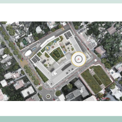
- New Hospital of “Penisola Sorrentina e della Costiera Amalfitana”, Municipality of Sant’Agnello (NA) – Transport Impact TRT Trasporti e Territorio was commissioned by Azienda Sanitaria Locale Napoli 3 Sud to carry out a Transport Impact Study related to the New Hospital of the Sorrento Peninsula and Amalfi Coast in the Municipality of Sant’Agnello. The aim of the project is to verify the impact generated on traffic in the study area, in order to highlight any critical issues on the future road network and identify possible solutions to mitigate them. The study also includes indications on parking. The traffic impact assessment analyzes the traffic flow conditions in two scenarios: the Existing Condition and, subsequently, the Project Scenario during the morning peak hour of a typical weekday. This assessment was conducted using a sophisticated dynamic micro-simulation tool for traffic flow, specifically implemented through PTV Vissim software. Through the modeling tool, the main transportation indicators necessary for evaluating the impact on flow quality compared to the current situation and identifying existing challenges were extracted and quantified. These indicators specifically include speed, delays, queue lengths, and Levels of Service. [tw_button icon=”” link=”http://www.trt.it/en/Projects/” size=”small” rounded=”false” style=”flat” hover=”default” color=”#223468″ target=”_self”]Projects[/tw_button]
- Drafting mobility scenarios for the Territorial Plan for the Metropolitan City of Naples TRTIng, grouped with Telos, Ambiente Italia, Geores, Nemo and Sociolab, was in charge of drafting the Territorial Plan of the Metropolitan (PTM) City of Naples. In particular, TRT supports the working group in analyzing the current assets of mobility and transport infrastructures and in defining future policies and interventions taking into account the SUMP (Sustainable Urban Mobility Plan) of the Metropolitan City currently being adopted. The PTM of the Metropolitan City of Naples wants to be a shared territorial project to effectively pursue the objectives of sustainable development and the reduction of land consumption, strengthening and enhancing the infrastructure networks and public mobility systems in synergy with the SUMP. The plan focuses on urban regeneration and on the redevelopment of the existing building heritage, the upgrading and redevelopment of services and public spaces, the construction of the metropolitan ecological network as well as the protection and enhancement of all landscapes.
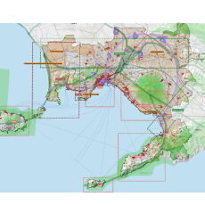
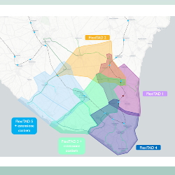
- Designing Demand Aligned Transportation System (TAD) of the South Salento Inland Area South Salento – Capo di Leuca is an association of 16 municipalities in Puglia located in the extreme southern tip of the province of Lecce. A territory among those selected by the National Strategy of Inner Areas (SNAI) in which about 125,000 people reside, characterized by phenomena of demographic decline and marginalization. One of the pivotal projects of the territorial cohesion and development strategy, financed through the SNAI with 3.5M€, involves the implementation of a “demand-aligned transport system (TAD)” based on three macro actions: the optimization of existing local public transport services to and from the inland area from the capital and other main service centers (suburban bus and rail service) the reorganization and enhancement of bus lines for connections between the municipalities in the area and between the hinterland and the coast the activation of an additional flexible collective transport service with minibuses (on demand or on call) TRT worked on the study to assess the mobility demand expressed by the area’s population and on the detailed design of the TAD system, including the definition of the operating and governance model and the features and functionality of the IT reservation platform. TAD study and project were based on the results of the European project HiReach, which investigated the issues of inclusive mobility and “mobility poverty” just in South Salento by also testing the first flexible transportation service in summer 2020 in collaboration with Ferrovie del Sud Est (Italian FS Group).
- Drafting of the Monitoring Report of the Sustainable Urban Mobility Plan of the Municipality of Piacenza. Verification of the status of implementation of SUMP measures and performance of indicators representative of the Plan objectives TRT was commissioned by the Municipality of Piacenza to draft the Monitoring Report of the current SUMP (Sustainable Urban Mobility Plan), approved by Municipal Council Resolution no. 57 of 28/12/2020. The activity consists in verifying the implementation status of the measures proposed by the SUMP and to provide the trend of the indicators representative of the plan objectives as selected by the MIT (Italian Ministry of Infrastructure and Transport) Guidelines. The Monitoring Report is functional to highlight the impacts on the mobility system and the environment, in order to establish a transparent relationship between the Administration, citizens and stakeholders on how the objectives identified in the Plan have been pursued. The monitoring activity was also an opportunity to assess the effectiveness of the proposed actions on the basis of the state of implementation of the SUMP and the results achieved so far, and at the same time to lay the foundations for the revision and updating of the SUMP. The activities were structured as follows: Reading the state of implementation of the measures foreseen by the current SUMP in both the Reference Scenario and the Plan Scenario highlighting the interventions completed, under construction, in the final and executive design phase or subject to feasibility studies, as well as the interventions not yet started; Estimation of the indicators provided by the current SUMP in order to identify the changes in the different time horizons examined: base year (2019), state of affairs (2023) and the trend with respect to the achievement of the 2030 targets. In particular, both the minimum indicators by the MIT, the additional indicators required by the Emilia Romagna Region, and the context indicators identified by the Piacenza SUMP were estimated. Finally, the Monitoring Report provides useful indications for the updating phase of the SUMP. In this regard, the targets to 2030 indicated by the current SUMP were compared with those indicated by the most recent instruments (PRIT 2025, PAIR 2030, and RER Strategy 2030) consistent with the choices made in the European and national arena. Based on these aspects, potential areas for intervention when updating the SUMP have been highlighted, with the update expected to be completed by December 2025, five years after its approval. Related projects: City of Piacenza, Sustainable Urban Mobility
